
|
Jump to your event
Staging Area
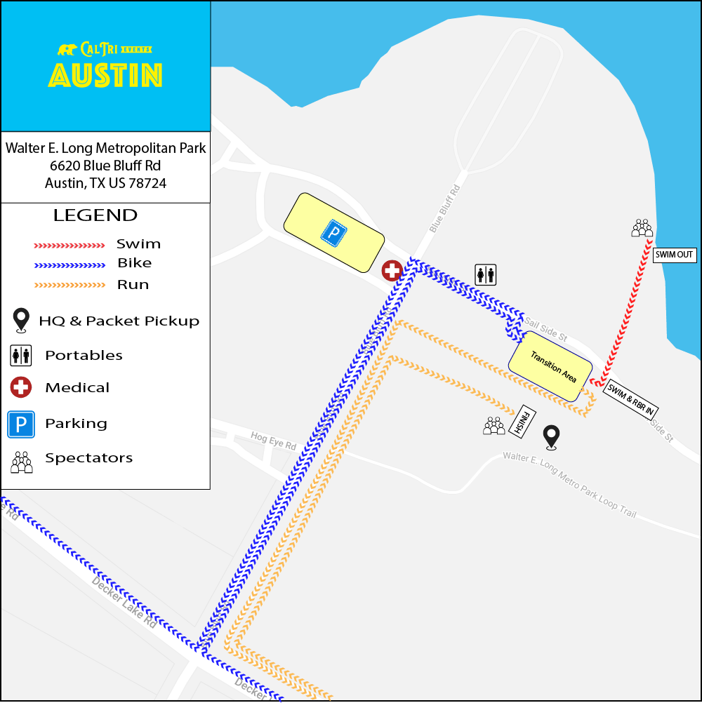
🔍 Click map to view full size in a new tab
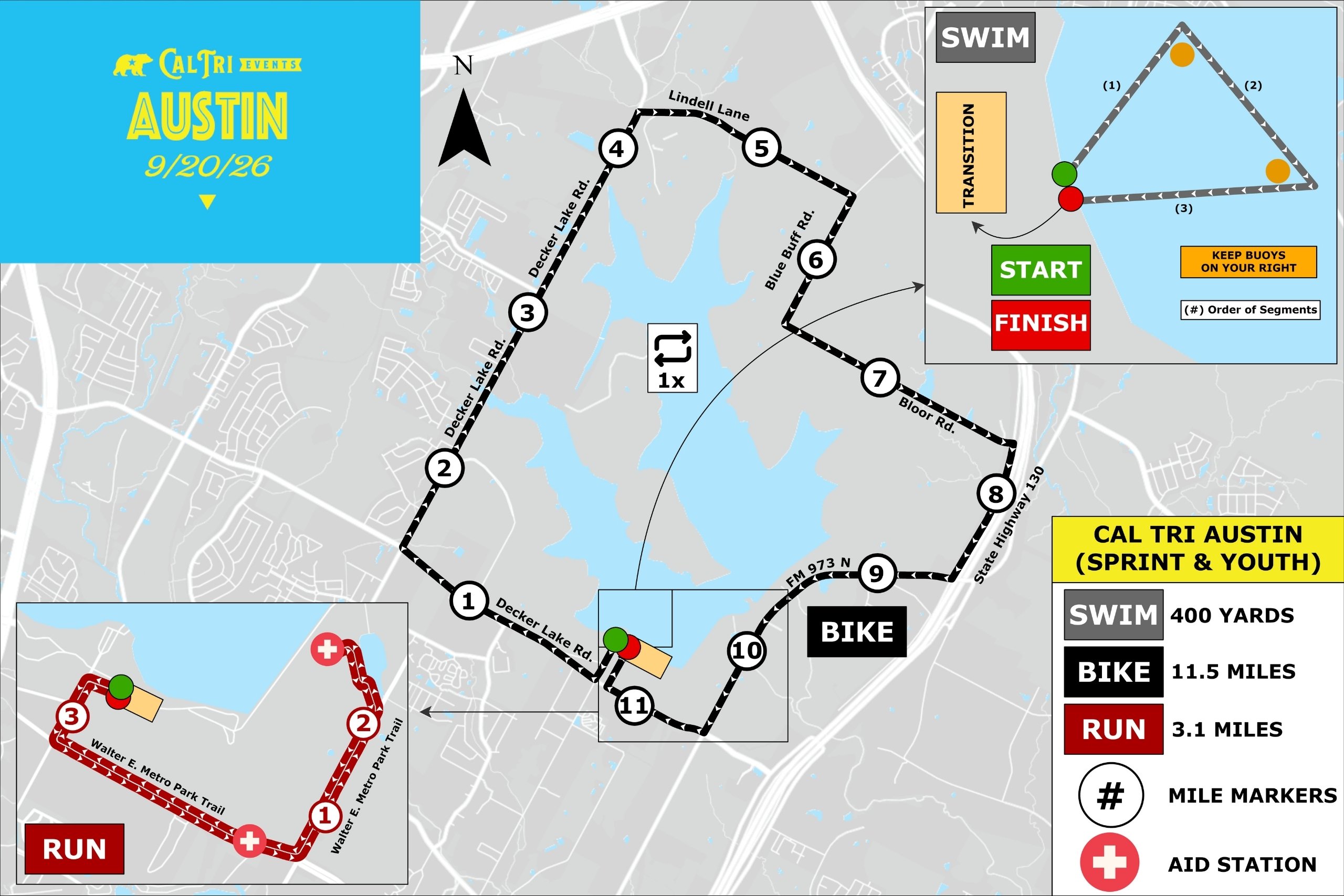
Sprint & Youth Distance Events
🏊🚴🏃 Sprint & Youth Triathlon
|
SWIM
400
yards
|
BIKE
11.5
miles
|
RUN
3.1
miles
|
📍 Start Location: Swim Beach
|
🔍 Click map to view full size in a new tab
🚴 Sprint Bike Cue Sheet
| 0.0 mi | Start on Blue Bluff Rd |
| 0.2 mi | Turn right onto Decker Lake Rd |
| 1.6 mi | Turn right onto Decker Ln |
| 4.3 mi | Turn right onto Lindell Ln |
| 5.7 mi | Turn right onto Blue Bluff Rd |
| 6.5 mi | Turn left onto Bloor Rd |
| 7.9 mi | Turn right onto Texas 130 Service Rd |
| 8.8 mi | Turn right onto FM973 S |
| 10.6 mi | Turn right onto Decker Lake Rd |
| 11.3 mi | Turn right onto Blue Bluff Rd → finish |
🏃🚴🏃 Sprint & Youth RunBikeRun
|
RUN 1
3.1
miles
|
BIKE
11.5
miles
|
RUN 2
3.1
miles
|
📍 Start Location: Finish Line Arch
📌 Reading this Map
The map below shows the full triathlon course for reference. As a RunBikeRun athlete, your race uses the black bike route and red run route only. Ignore the grey swim route.
|
🔍 Click map to view full size in a new tab
🚴 Sprint Bike Cue Sheet
| 0.0 mi | Start on Blue Bluff Rd |
| 0.2 mi | Turn right onto Decker Lake Rd |
| 1.6 mi | Turn right onto Decker Ln |
| 4.3 mi | Turn right onto Lindell Ln |
| 5.7 mi | Turn right onto Blue Bluff Rd |
| 6.5 mi | Turn left onto Bloor Rd |
| 7.9 mi | Turn right onto Texas 130 Service Rd |
| 8.8 mi | Turn right onto FM973 S |
| 10.6 mi | Turn right onto Decker Lake Rd |
| 11.3 mi | Turn right onto Blue Bluff Rd → finish |
🏊🚴 Sprint & Youth SwimBike
|
SWIM
400
yards
|
BIKE
11.5
miles
|
📍 Start Location: Swim Beach
📌 Reading this Map
The map below shows the full triathlon course for reference. As a SwimBike athlete, your race uses the grey swim route and black bike route only. Ignore the red run route.
|
🔍 Click map to view full size in a new tab
🚴 Sprint Bike Cue Sheet
| 0.0 mi | Start on Blue Bluff Rd |
| 0.2 mi | Turn right onto Decker Lake Rd |
| 1.6 mi | Turn right onto Decker Ln |
| 4.3 mi | Turn right onto Lindell Ln |
| 5.7 mi | Turn right onto Blue Bluff Rd |
| 6.5 mi | Turn left onto Bloor Rd |
| 7.9 mi | Turn right onto Texas 130 Service Rd |
| 8.8 mi | Turn right onto FM973 S |
| 10.6 mi | Turn right onto Decker Lake Rd |
| 11.3 mi | Turn right onto Blue Bluff Rd → finish |
🏊🏃 Sprint & Youth SwimRun
|
SWIM
400
yards
|
RUN
3.1
miles
|
📍 Start Location: Swim Beach
📌 Reading this Map
The map below shows the full triathlon course for reference. As a SwimRun athlete, your race uses the grey swim route and red run route only. Ignore the black bike route entirely. After your swim you go directly into the run, with no bike leg.
|
🔍 Click map to view full size in a new tab
Course Files on Ride with GPS
🏊 Swim Course🏃 Run Course🏊 Sprint Swim
|
SWIM
400
yards
|
📍 Start Location: Swim Beach
📌 Reading this Map
The map below shows the full triathlon course for reference. As a 400 Yard Swim athlete, you complete the grey swim route only. Ignore the bike and run portions of the map entirely.
🔍 Click map to view full size in a new tab
Course Files on Ride with GPS
🏊 Swim Course🏃 5K Run
|
RUN
3.1
miles
|
📍 Start Location: Finish Line Arch
📌 Reading this Map
The map below shows the full triathlon course for reference. As a 5K Run athlete, you follow the red run route only. Ignore the swim and bike portions of the map entirely.
🔍 Click map to view full size in a new tab
Course Files on Ride with GPS
🏃 Run CourseOlympic Distance Events
🏊🚴🏃 Olympic Triathlon
|
SWIM
1,640
yards
|
BIKE
22.6
miles
|
RUN
6.1
miles
|
📍 Start Location: Swim Beach
|
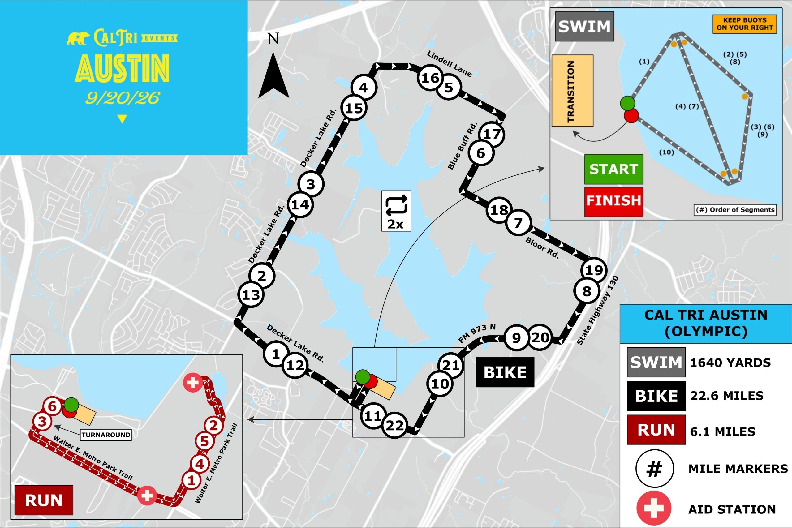
🔍 Click map to view full size in a new tab
🚴 Olympic Bike Cue Sheet
| 0.0 mi | Start on Blue Bluff Rd |
| 0.2 mi | Turn right onto Decker Lake Rd |
| 1.5 mi | Turn right onto Decker Ln |
| 4.3 mi | Turn right onto Lindell Ln |
| 5.6 mi | Turn right onto Blue Bluff Rd |
| 6.5 mi | Turn left onto Bloor Rd |
| 7.9 mi | Turn right onto Texas 130 Service Rd |
| 8.7 mi | Turn right onto FM973 S |
| 10.6 mi | Turn right onto Decker Lake Rd (loop 1 continues) |
| 12.6 mi | Turn right onto Decker Ln |
| 15.4 mi | Turn right onto Lindell Ln |
| 16.7 mi | Turn right onto Blue Bluff Rd |
| 17.5 mi | Turn left onto Bloor Rd |
| 19.0 mi | Turn right onto Texas 130 Service Rd |
| 19.8 mi | Turn right onto FM973 S |
| 21.7 mi | Turn right onto Decker Lake Rd → finish |
🏃🚴🏃 Olympic RunBikeRun
|
RUN 1
3.1
miles
|
BIKE
22.6
miles
|
RUN 2
6.1
miles
|
📍 Start Location: Finish Line Arch
📌 Reading this Map
The map below shows the full Olympic triathlon course for reference. As an Olympic RunBikeRun athlete, your race uses the black bike route and red run route only. Ignore the grey swim route.
Run #1 is one loop of the run course before heading to the bike.
Run #1 is one loop of the run course before heading to the bike.
|
🔍 Click map to view full size in a new tab
🚴 Olympic Bike Cue Sheet
| 0.0 mi | Start on Blue Bluff Rd |
| 0.2 mi | Turn right onto Decker Lake Rd |
| 1.5 mi | Turn right onto Decker Ln |
| 4.3 mi | Turn right onto Lindell Ln |
| 5.6 mi | Turn right onto Blue Bluff Rd |
| 6.5 mi | Turn left onto Bloor Rd |
| 7.9 mi | Turn right onto Texas 130 Service Rd |
| 8.7 mi | Turn right onto FM973 S |
| 10.6 mi | Turn right onto Decker Lake Rd (loop 1 continues) |
| 12.6 mi | Turn right onto Decker Ln |
| 15.4 mi | Turn right onto Lindell Ln |
| 16.7 mi | Turn right onto Blue Bluff Rd |
| 17.5 mi | Turn left onto Bloor Rd |
| 19.0 mi | Turn right onto Texas 130 Service Rd |
| 19.8 mi | Turn right onto FM973 S |
| 21.7 mi | Turn right onto Decker Lake Rd → finish |
🏊🚴 Olympic SwimBike
|
SWIM
1,640
yards
|
BIKE
22.6
miles
|
📍 Start Location: Swim Beach
📌 Reading this Map
The map below shows the full Olympic triathlon course for reference. As an Olympic SwimBike athlete, your race uses the grey swim route and black bike route only. Ignore the red run route.
|
🔍 Click map to view full size in a new tab
🚴 Olympic Bike Cue Sheet
| 0.0 mi | Start on Blue Bluff Rd |
| 0.2 mi | Turn right onto Decker Lake Rd |
| 1.5 mi | Turn right onto Decker Ln |
| 4.3 mi | Turn right onto Lindell Ln |
| 5.6 mi | Turn right onto Blue Bluff Rd |
| 6.5 mi | Turn left onto Bloor Rd |
| 7.9 mi | Turn right onto Texas 130 Service Rd |
| 8.7 mi | Turn right onto FM973 S |
| 10.6 mi | Turn right onto Decker Lake Rd (loop 1 continues) |
| 12.6 mi | Turn right onto Decker Ln |
| 15.4 mi | Turn right onto Lindell Ln |
| 16.7 mi | Turn right onto Blue Bluff Rd |
| 17.5 mi | Turn left onto Bloor Rd |
| 19.0 mi | Turn right onto Texas 130 Service Rd |
| 19.8 mi | Turn right onto FM973 S |
| 21.7 mi | Turn right onto Decker Lake Rd → finish |
🏊🏃 Olympic SwimRun
|
SWIM
1,640
yards
|
RUN
6.1
miles
|
📍 Start Location: Swim Beach
📌 Reading this Map
The map below shows the full Olympic triathlon course for reference. As an Olympic SwimRun athlete, your race uses the grey swim route and red run route only. Ignore the black bike route entirely. After your swim you go directly into the run, with no bike leg.
|
🔍 Click map to view full size in a new tab
Course Files on Ride with GPS
🏊 Swim Course🏃 Run Course🏊 Olympic Swim
|
SWIM
1,640
yards
|
📍 Start Location: Swim Beach
📌 Reading this Map
The map below shows the full Olympic triathlon course for reference. As an Olympic swim athlete, you complete the grey swim route only. Ignore the bike and run portions of the map entirely.
🔍 Click map to view full size in a new tab
Course Files on Ride with GPS
🏊 Swim Course🏃 10K Run
|
RUN
6.2
miles
|
📍 Start Location: Finish Line Arch
📌 Reading this Map
The map below shows the full Olympic triathlon course for reference. As a 10K Run athlete, you follow the red run route only. Ignore the swim and bike portions of the map entirely.
🔍 Click map to view full size in a new tab
Course Files on Ride with GPS
🏃 Run Course