Course Descriptions
The purpose of the West of the River Series is to highlight points in Monroe County, NY that are west of the Genesee River. Our host towns (Hilton, Greece, and Spencerport) each offer a unique feel. Following are the course links and general descriptions of the courses. After that are links to additional route options for training and to see various areas west of the river. Please Note: None of our courses have closed roads! All of them have some portion where sidewalk use is advantageous. Tangent cutting is a common practice, but it is inadvisable when traffic is present. Cars ALWAYS win, even if you have the right of way.
As we get closer to each race day it's possible something unexpected might cause an alteration. If that happens, I'll update here, via e-mail, and through the Facebook group.
June Jaunt (5K)
Map
View the course at https://www.mapmyrun.com/routes/view/5556356155 to see elevation profile and mileage markers. Course not certified, although it is accurately measured to ensure 3.11 miles, regardless of folks' watch data.
Course Description
Relatively flat with long, straight stretches, many of which are through open, country areas. All portions are paved. Starts at Studio 22 Fitness from the west side of the building, heading west along Old Hojack, south on Collamer, east on West Ave. From there, racers make a detour from the long stretches visiting the Village Elementary School neighborhood before returning to West Ave, doing a short bit going north on Lake Ave, and returning to Studio 22 to cross the finish line on the east side of the building. Except when racers get to the offshoot for the school section, the turns are all lefts.
Start/Finish/Aid Station/Restrooms
The start line and finish line are on opposite sides of the building. The start line is in the parking lot near the Studio 22 entrance. About halfway through the course, there is an aid station with water and Gatorade. Bringing your own bottle is recommended, although we do provide cups. Turning left nearly continuously on the course, the finish line is on the left BEFORE you get to the building. If you were to pass that lot, you'd overshoot the finish and go back to the start. Restrooms are available in Studio 22 as are showers. There are no facilities on the course. Refreshments after the race include water and Gatorade.
The Potato Run (10K)
Map
View the course at https://www.mapmyrun.com/routes/view/6225550420 to see the elevation profile and mileage markers. Course not certified, although it is accurately measured to ensure 3.11 miles, regardless of folks' watch data.
Course Description
The Potato Run is paved except the parts on the canal path, which is largely packed earth with fine gravel in parts and occasional small sections of asphalt or concrete. Road shoes recommended. Trail shoes would be too aggressive. Racers face traffic, except when on the short stretch of sidewalk in the area of Ridgeway and Long Pond.
The course starts across from the Towpath Shelter, heads left around the traffic circle (crossing to the right to stay on the traffic circle), heads uphill to the Rotary Lodge, continues around the traffic circle before heading left to the Grasso Lodge cul de sac, then turning left at the one-way traffic circle and heading out of the park. Next, you traverse the inclining Elmgrove Road before turning onto Ridgeway for rolling hills. Scooting across the road to access the sidewalk almost directly across from New Comer Funeral Home, you continue to the stop light to turn right on Long Pond. Keeping to the sidewalk, you'll turn right at the light on Long Pond to the gated righthand Erie Canal Path entrance/exit just before the bridge, which leads racers for more nearly two miles along the canal passing Henpeck Park to return to the paved pathway of Greece Canal Park. From there, it's nearly all downhill, turning left immediately after the red restroom, and crossing the crosswalk to the finish line.
Start/Finish/Aid Station/Restrooms
The start line is on the pathway between the red restroom building and the canal path, facing the one-way traffic circle. Pre-race restrooms are in the aforementioned red restroom building. Approximately 1.75 miles in, you will pass Henpeck Park, which is across the road and has a portable toilet available in the parking lot. Be careful crossing as there is no crosswalk. The aid station is about halfway through the course and accessible from the sidewalk after you turn onto Long Pond Rd. It offers water and Gatorade. About the 5.5-mile mark, you'll approach Henpeck Park again, this time from the canal path, giving you access to the portable toilet for a second time. Get back on the canal path afterwards to continue to Greece Canal Park. Water and Gatorade are among the refreshments back at Towpath Shelter.
Barbecue Bash Quarters (1-4 Quarters of a Marathon: 6.55 Miles, 13.1 Miles, 19.65 Miles, or 26.2 Miles)
Certifications
This is a certified course for those seeking records or qualifying times for races such as the Boston Marathon.
USATF: NY24008KL
World Athletics: USA-2024-227
Map
View the course at https://www.mapmyrun.com/routes/view/5811055855 to see the elevation profile and mileage markers. There's also a PDF at the bottom of this page showing aid stations and expected Road Marshal stations.
Course Description
Headquartered at Spencerport Depot and Canal Museum (SDCM), racers start along the canal in front of SDCM on Heritage Trail. A portion of the trail is paved and the rest of the trail is packed earth with fine gravel. That's less than a mile of the course. The rest is paved. Road shoes recommended. Trail shoes would be too aggressive.
You take off heading west along a lovely route throughout Village of Spencerport's quiet residential neighborhoods, returning to BUT NOT STOPPING at the starting area, and continuing east on the trail along the canal, making a U-turn to return westward to the finish/lap line. This makes for a flat start and finish punctuated with a variety of hills from a bit on the steep side to gently inclining and declining. The 6.55-mile (quarter marathon) route is done up to four times, allowing racers from the front of the pack to the back of the pack to see each other at various points.
Start/Finish/Laps/Aid Station/Restrooms
The start line is on the paved portion of Heritage Trail across from the main (upstairs) entrance of SDCM. When racers are working on the sixth mile of each lap, they will PASS the start/finish/lap line to continue east on the trail to the U-turn point, where they will once again head toward SDCM. Due to the repeating nature of this course, racers finishing their laps cross the timing mat at the conclusion of each lap. If they are done with their race, they veer left toward the building; if they are starting a new lap, they veer right to continue west along the path back toward S. Union St.
Aid stations are at three points: near the start line on the south side of the path, at about two miles into the lap across from the intersection of Coventry and Kirkgate, and about 5.5 miles in after you pass the start line and before you make the U-turn on the Heritage Trail to get back to the start/new lap/finish line. Each has water and Gatorade as does the post-race refreshment area.
There are bathrooms at the race headquarters (Spencerport Depot and Canal Museum), which is where each 6.55-mile lap begins and ends. Restrooms are located in the lower level of the depot, a short walk off the course. You pass HQ about 5.5 miles in before making the U-turn on Heritage Trail, which brings you back to it at 6.55 miles, giving you access to them twice each lap. That puts the miles at which you have access to the indoor toilets at approximately: Mile 0, Mile 5.5, Mile 6.55, Mile 12.05, Mile 13.1, Mile 18.6, Mile 19.65, Mile 25.15, and Mile 26.2.
We will have a portable toilet at the corner of West Ave. and Evergreen St. inside the gates for the DPW, a few steps off the course as you'd turn right onto Evergreen. That provides additional access at approximately: Mile 4.5, Mile 11.05, Mile 17.6, and Mile 24.15.
Between the two locations, at 12 minutes per mile, you'd never be more than about 54 minutes without access. At 20 minutes per mile, you'd never be more than 1 hour, 30 minutes without toilet access.
The Barbecue Bash Quarters map below is slightly out of date with the change for certification for 2024. As the map on MapMyRun shows, the left turn toward RM 12 no longer exists and instead of going right at RM 15, racers continue to the end of that road, run around the teardrop shape of the cul de sac, and return to RM 15 where they now turn left to continue the rest of the course as shown.
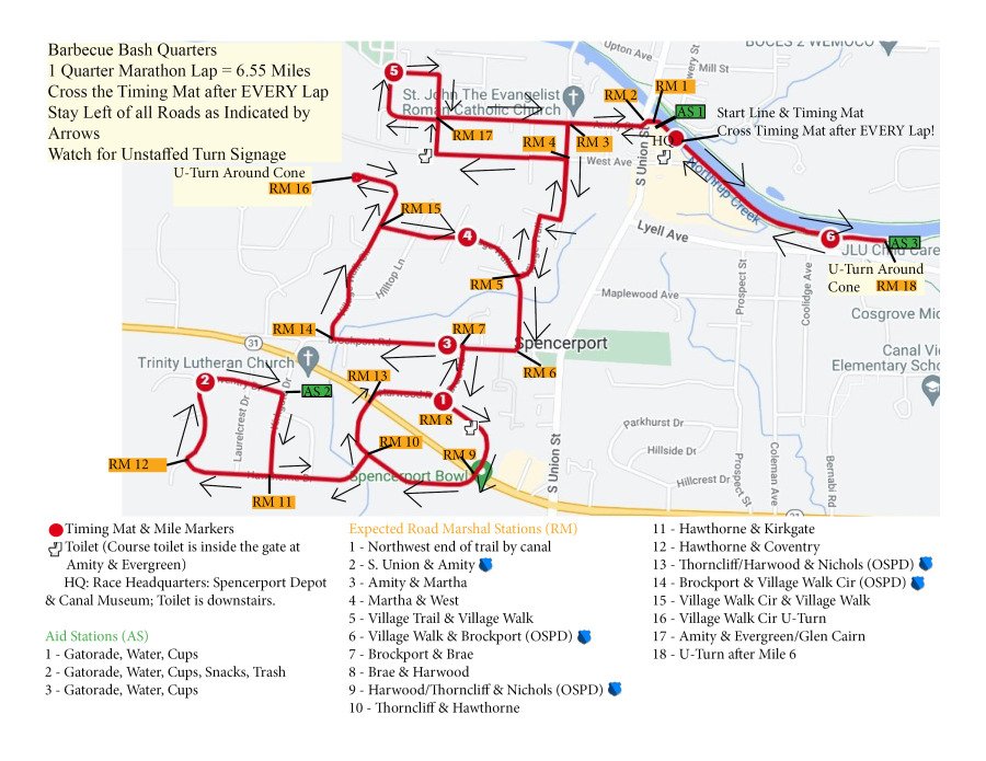
Be sure to follow any route arrows or signs when approaching intersections with no volunteers, especially with Barbecue Bash Quarters, where there are several turns. Turn directions for BBQ are in the PDF at the bottom of this page. They will be updated for 2024.
Additional paths for training and enjoying Hilton, Greece, and Spencerport areas.
Hilton
3.1 Miles https://www.mapmyrun.com/routes/view/2488553404 (Course from 2022, based at Jennejahn Lodge)
3.1 Miles https://www.mapmyrun.com/routes/view/2480441971
3.1 Miles https://www.mapmyrun.com/routes/view/2480465977
Greece
6.2 Miles https://www.mapmyrun.com/routes/view/2883945598
6.2 Miles https://www.mapmyrun.com/routes/view/2950617805
Spencerport
13.1 Miles https://www.mapmyrun.com/routes/view/2725817980
6.55 Miles https://www.mapmyrun.com/routes/view/4686479797
